
Singapore MRT Lines : Current and Future Lines Complete Guide
MRT is a godsend even in tiny Singapore.
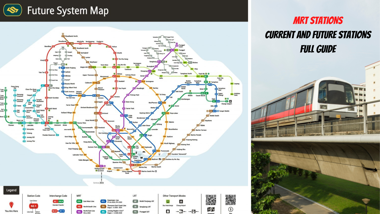
The first MRT line is the North-South line, with only 5 stations connecting Yio Chu Kang to Toa Payoh. Today, we have 6 MRT lines with over 170 stations and 3 LRT Lines with over 40 stations. There will be an additional 2 more lines and other stations to existing lines in the future. The main MRT lines are often identified by their colours instead of their generic names for easy reference.
This is an impressive feat for a country that is only 728.6km. In the past, staying near an MRT would probably send the property price soaring; today, the impact is lessened, especially when most visit within 1km of an existing or future MRT line.
With the proliferation of MRT stations, one may get lost. So here is a quick guide to the Current and Future MRT stations.
Current Line

|
| Current MRT Line |
As of September 2022, 6 MRT lines and 3 LRT times are operational. They are as follows.
North South Line (NSL) - RED LINE
27 Stations, 42 km
1987

First MRT line in Singapore. There are currently 27 stations covering 45 km, with 2 additional stations to be built by mid-2030. Brickland and Sungei Kadut Station Sungei Kadut interchange station will be between Kranji and Yew Tee and will link up with DTL. It is also the last stop for the downtown line.
As the name implies, this line travels the North-South route of Singapore. It has since expanded from Jurong East to Marina South Pier.

There are a total of eight interchanges that connect the NSL to the other lines.
East-West Line- City Hall, Raffles Place, Jurong East
Circle Line -Marina Bay, Doby Ghaut
North East Line -Dobby Guat
Bukit Panjang LRT- Choa Chu Kang
Thomson East Coast Line (TEL) - Orchard Station (2024)
East-West Line (EWL) - GREEN LINE
35 Stations, 57km
1987

The EWL is the 2nd MRT line in Singapore and is currently Singapore's longest MRT line at 57.2km. There are a total of 35 stations, of which 8 are underground. As the name implies, it connects the West to the East of Singapore from Tuas Link to Changi Airport and Pasir Ris.

|
| Source: LTA |
There are a total of 9 interchanges that connects EWL
Downtown Line -Tampines, Changi Airport, Bugis
North-South Line-City Hall, Raffles Place, Jurong East
Circle Line -Bouna Vista, Paya Lebar
North East Line -Outram Park.
Thomson East Coast Line (TEL) - Outram Park (2024)
North-East Line (NEL) - Purple Line
16 Stations, 20km
2003

With 16 stations over 20km from Punggol to Harbourfront, this is Singapore's first fully automated underground rail line. This is also the shortest MRT line in Singapore. There are plans to extend the line to Punggol North, which should be completed by 2024.
While the line does not stop at Sentosa, You can transfer to the Sentosa Monorail at Harbourfront.

There are a total of 6 interchanges on this line.
East-West Line -Outram Park
Circle Line -Serangoon, Dhoby Ghaut, Harbourfront
Downtown Line -Little India, Chinatown
Circle Line (CL) - ORANGE LINE
30 Stations - 35KM
2009

The Circles line is not a complete loop. This line connects to all other lines with 30 stations in a circular network. The start point is from Marina Bay and Dhoby Ghaut, ending at Harbourfront. There are plans to close this loop with a connection from HabourFront to Marina Bay by 2026. In addition, 3 additional stations ( Keppel, Cantonment and Prince Edward) are planned in this final phase.
Unlike how it is depicted on the MRT map, the circle line is not a complete circle.
.png)
Given that this is essentially a line that connects all other lines, there are 11 interchanges on this line. So in terms of connectivity, residents on this line have the best connectivity to Singapore.
North-South Line - Bishan, Dobby Ghaut, Marina Bay
East-West Line - Paya Lebar, Buona Vista
North-East Line - Serangoon, Dhoby Ghaut, Harbourfront
Downton Line - MacPherson, Promenade, Bayfront, Botanic Garden
Thomson-East Coast Line - Marina Bay, Caldecott
Downtown Line (DL) - Blue Line
36 Stations - 42 Km
2013

The Downtown line has 36 stations over a length of 42 km. This was a game changer in public transport, bringing residents from East to West to the CBD area. It was initially planned as 3 separate lines, but I am now merged into one. It currently starts from Bukit Panjang to Expo.
Sungei Bedok will begin operations in 2024, while a new infill station, Hume Station, will open in 2025. An extension to Sungei Kadut is scheduled to open in 2030.

There are a total of 11 interchanges on this line. Like the circle line, it also directly connects to the other 5 major lines.
North-South Line - Newton
East-West Line - Tampines, Expo, Bugis
North-East Line - Chinatown, Little India
Circle-Line- Botanic Garden, Bayfront, Promenade
Thomson-East Coast Line - Stevens
Thomson-East Coast Line (TEL) - Brown Line
32 Stations, 43 km
2020

Thomson East Coast Line will have 32 stations over 43 km. This line is dubbed the Game Changer for residents living along the Marine Parade and East Coast road, as there was a lack of connectivity for MRT along this stretch. It stretches from Woodlands North to Changi Airport (2040).
Currently, this line will be opened in 5 stages. Stage 1-3 is expected to open from Woodlands North to Caldecott by Q3 2022. A proposed station to Changi Airport will eventually merge this line with the East-West line. This will be commerce by 2040.

.png)
Bukit Panjang is Singapore's first Light rail and connects estates within Bukit Panjang and Chia Chu Kang to the North-South and Downtown lines.
Sengkang- Punggol LRT
2005

A fully driverless system will connect Sengkang and Punggol to Sengkang and Punggol MRT, respectively.
FUTURE LINES

|
|
Source: LTA |
If you think the current lines are already enough connectively, you would be shocked that there will be another 2 main lines to be added.
Jurong East Line (JEL) - Turquoise
2026

A new line in the West with the Jurong Region line will exist. This will have a total of 24 stations over 24km, connecting the new town of Tengah to Jurong East Interchange. There are plans to connect NTU to the MRT line for this stage.

|
| Source: LTA |
Singapore's seventh line is expected to be completed by 2029.
Cross Island Line - Light Green Line
2030
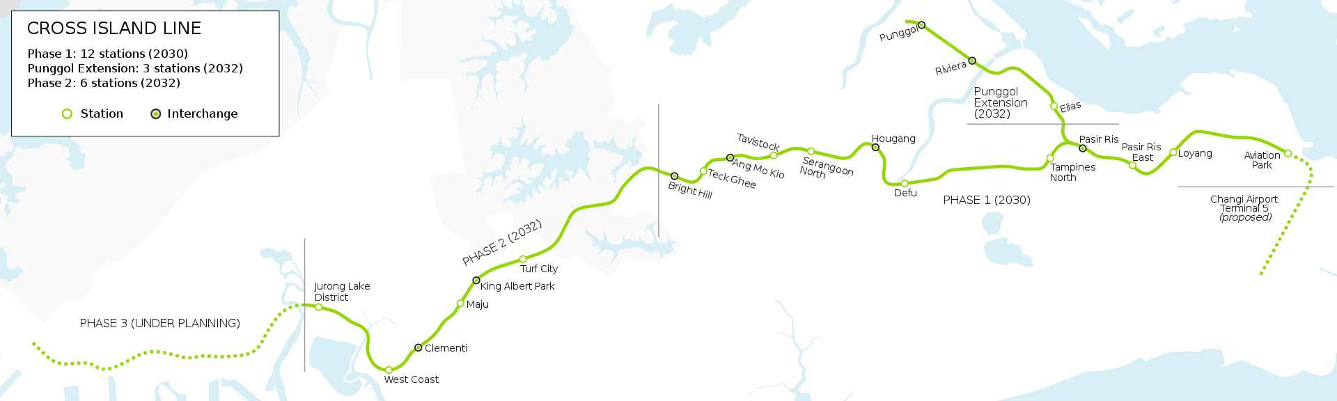
Once completed, the Cross Island Line will be the longest fully underground line, over 50km long. It will connect major hubs such as Jurong Lake District, Punggol Digital District and Changi Region. Currently, there are over 30 stations slated for this line, and more may be confirmed later.

This will be the roadmap of future MRT Lines

Are we done yet?
While the tracks have been laid till 2030, there are still pockets in Singapore that could be better served by the MRT network. For example, with Paya Lebar's air base relocated, a vast 800-ha area will be developed. Currently, yet to be any stations are planned for this stretch though Cross Island Line would pass through this area.
In the future, we could extend beyond our shores with lines connecting to Malaysia and beyond. That may be after our time, but one for the next generation.
![]()


Can we know what mrt lines in 2040 and 2050
ReplyDeleteOther than Changi Airport linking to TEL in 2040, nothing has been announced. We are pretty much connected with the proposed lines. Maybe by 2040-2050, we might end up taking flight ala the movie Back to the future 😄
ReplyDelete